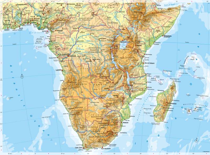
Southern Africa - Physical map
Physical map
978-3-14-100890-6 | Page 154 | Ill. 1
Overview
Almost all of South and East Africa lies at relatively high altitudes. Larger plains exist only on the east coast to the Indian Ocean. In contrast to many other continents, settlement is less oriented towards the coasts, exceptions being South Africa and the Gold Coast.
The zonal change in the landscape typical of the part of Africa north of the equator (from the rainforest of the Congo Basin to the savannahs of the Sahel to the deserts of the Sahara) is modified more strongly by the relief, the mountains and the exposure to the major wind systems in the south. The contrast between the east and west coasts is particularly striking. It is caused by very different climatic conditions. While the east coast regularly receives high precipitation upwind from trade winds, the west coast is dominated by wind currents parallel to the coast and the cold Benguela Sea Current, so that only very little precipitation falls there.
Tectonic structures in Southern Africa
The south of Africa is formed by a very old and tectonically quiet shield. It is - even more clearly than the northern part of Africa - divided into basins and sills, whereby the mountain frames of the basins are sometimes very high (e.g. Drakensberg). Among the basins, the most prominent are the Upper Nile Basin, the Congo Basin and the Kalahari Basin. The Congo Basin is about 3.7 million square kilometres in size, covering one eighth of Africa's land area. It has a closed mountainous border (with heights of up to 2000 m), followed towards the centre by an escarpment and the lowest-lying central basin area around Mbandaka (around 400 m above sea level). In the west, the Congo breaks through the low Guinea sill, which is over 1000 metres high.
The Kalahari Basin covers an area of about 2.5 million square kilometres, which is about one-twelfth of Africa's land area. It is contracted by the Congo Basin because of the climatic conditions. While extensive deserts and savannahs dominate the picture here, there it is extensive tropical rainforests. The marginal mountains of the large basins are widely rich in raw materials. The surface structures of the basins and mountain ranges are followed by the water network (Congo basin river system, in the southern Kalahari basin: Wadis and the Okavango River ending there in an inland delta).
The subspace of basins and sills in the west is contrasted in the east by the highlands and rift structures determined by active tectonics and volcanism. Starting from the Gulf of Aden, a plate boundary runs like a crack through the African Plate and encloses the small Victoria Plate there. The subsoil, which is broken into floes, is partly subject to uplift and partly to subsidence processes. This has led to the formation of trench structures, which can be traced particularly well in the east of the Victoria Plate in the form of elongated lakes. In geological time, a narrow sea similar to the Red Sea could initially open up here, which in turn could be the initial stage of an ocean formation. The greatest heights in the south of the continent are reached at Kilimanjaro and the other great volcanoes of East Africa, as well as in the Drakensberg Mountains.
Madagascar and the surrounding island groups form a separate sub-region. Madagascar is about 1.7 times the size of Germany but has only a third as many inhabitants. In some respects, the island seems like a miniature southern Africa. The mountainous interior of the island, up to 2876 metres high, is bordered by narrow coastal plains. Climatically, there is a clear west-east contrast. While trade winds from the southeast provide year-round precipitation on the eastern side (Luve effects on the mountains), the west of the island only receives rain in the southern summer and is therefore drier. Due to its isolation from Africa, Madagascar has its very own fauna and flora with numerous endemic species.
The Cape region is comparatively young (the Cape Mountains folded up during the Cretaceous period around 85 million years ago) and differs greatly in climate and vegetation from the rest of southern Africa. It is more similar to the Mediterranean than to the basins and sills immediately to the north.
Special features
- The highest mountain on the map is Kilimanjaro (5895 m).
- Wadis (dry valleys in which water rarely flows) are visible in the Kalahari and Namib deserts.
-Lake Victoria, at around 69,000 square kilometres, is about twice the size of Belgium.
- In the ruined city of Great Zimbabwe, you can see the remains of a city that flourished between the 11th and 15th centuries and was the capital of a Bantu kingdom.
- The name "Cape of Good Hope" refers to the great voyages of discovery in the 15th century and shows the confidence of having found a sea route from Europe to Asia.
- The place names in South Africa give clues to the country's exploration and colonial history.
- There are long reservoirs on the Zambezi River.
- Lesotho is a country completely surrounded by another country (South Africa).